25 February 2008

Shots of the Day: 25.02.08

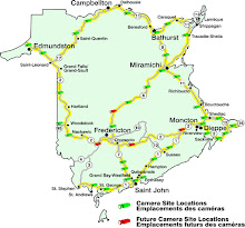
Well OK, it was a grey day and not one that was the best for capturing great photos by highway cameras. I checked Google Earth to see if I could identify where the highway cameras were located and I found a few of them.

To my eye the Durham Bridge camera is on an intersection looking downhill and east.


And I think that this is the Google Earth view of the location. I have marked it with a red circle and indicated the sight line of the camera with a line.


The Dieppe camera also looks east towards Sackville and is located inside the loop of the highway intersection with the highway to Shediac.


The highway camera at the highway bridge over the Saint John River from Coytown to Sheffield is close to the highway on the north said of the highway.


The Aroostook River camera seems to be located looking north and uphill over the Aroostook River. There is a barn visible to the hard right that I think is identifiable in the Google Earth view.

The Copp Loop Road highway camera is not as easy to identify and I am not sure about the location for this one. The farm seems to consist of a long older barn parallel to the road as in the Google Earth view and there are few candidates for the camera location.


The problem of course with Google Earth is that there are very few areas of high resolution in New Brunswick. The locations above are the ones that I am most sure of in high resolution areas. The cameras at the intersection of highway 95 and 540 is in a high resolution area but I could not be sure of the location. The camera looks west and is in a wooded section of divided highway and the only section that fits that description is too close to Woodstock to fit the description of being near the intersection.

The Saint John, Pennfield Ridge and Cape Pele cameras are likely in high resolution areas but their camera fields of view are so non-descript that I cannot be sure of their location. The other cameras all appear to be in lower resolution areas and can only be vaguely located.

Shots of the Day: 24.02.08

On the run but noticed that the Moon and the Sun set in the exact same spot at the intersection of Highways 95 and 540. This camera is rapidly becoming my favorite for sky and night observations.


22 February 2008

Shots of the Day: 22.02.08

I had the oppotunity on Wednesday to actually use the highways cameras to help me decide to drive to Fredericton. I checked in to see the condition of the highways using the highway cameras and based on the bright sunny weather and the clear pavement shown on the cameras I set out. What I discovered was that the night before there had been an unforecast 5 cm of snow that the Highway People decided to ignore. That meant that there was a slick and treacherous layer of packed snow on the highway in the Moncton area and though I never saw a salt truck or plow it only ended when I drove up onto the MRDC highway. After that is was clear wet pavement that you could drive on at regular highway speeds. I guess the disclaimer is necessary what the cameras show is not what you will experience.
The Moon was back in the frame over the highway at the Brun Way HWY95 X 540 camera.

And the planet was back over the Brun Way Quisbis Hill Camera.


In both cases the different times and locations for the appearance, location and setting of the object would make for an interesting exercise for a high school science class. The same would be true for sunrise and sunset since both are captured in some of the cameras.

The camera at Sheffield - Coytown needs to be visited by the MRDC people. It looks like the camera has tilted at a crazy angle and only captures a small fragment of the highway and the colour balance and focus have gone bad.


The camera has gone from a "must monitor" camera to a majour disappointment. On the other hand the province is bringing its cameras back on line and I see the St. Margarets camera is back.

Yesterday the cameras captured the first human image that I have seen so far in the person of a snowmobiler just running off the bottom of the frame at the HWY95 /540 Brunway location.


Just a word on the Brun Way cameras. The Meductic camera is just a bad camera setup while the Aroostook River is one of my top three views. They give a larger more detailed view but I think they all have a heavy light filter on them that makes everything dim unless it is direct sunlight.

This morning the highways are deserted. At 11:30 in the morning on Friday I think we have the most deserted set of highway photos taken so far. Go figure.

21 February 2008

Fredericton Has Web Cameras Also

To give the New Brunswick cities their fair treatment Fredericton has four active web cameras. Three are from the Fred-eZone service and feature constantly updated images of:
the North Side riverfront.


There is also a Fredericton web camera from Fred-eZone with a view of the street in front of City Hall.


Link to web camera

And finally Fred eZone has a web camera with a view of Officers Square where there are often concerts and public events but in the winter is flooded to make a skating rink.

Link to web camera

The final Fredericton web camera is hosted by the Atlantic Forestry Center and it has a view from the roof of their building.


Link to web camera

Found on the Web: Another NB Web Camera

Found this web camera on the CBC New Brunswick webpage. Nice shot of streets looking out Saint John Harbour. It is also updated on a one minute cycle. Fits into catagory # 4 and #6 I'd say.


Not an Eclipse but Still Cool

Last night was the night for the most spectacular lunar eclipse. It may have been cold but it could not have given us a clearer view. On the other hand, the NB Highway cameras were capturing other heavenly bodies.

Like the Moon over Highway 95.


And this must be a planet over Quisbis Hill. Look closely in the upper right hand corner.